 |
Hauptabteilung für die Sicherheit der Kernanlagen
Division principale de la Sécurité des Installations Nucléaires
Divisione principale della Sicurezza degli Impianti Nucleari
Swiss Federal Nuclear Safety Inspectorate |
 |
Eidgenössiche Technische Hochschule
Ecole polytechnique fédérale de Zurich
Politechnico federale svizzero di Zurigo
Swiss Federal Institute of Technology Zurich |
Ladislaus Rybach, Georg F. Schwarz, Fausto Medici
Construction of radioelement and dose-rate baseline maps by
combining ground and airborne radiometric data
Contents
Abstract
1 Introduction
2 Input Data
2.1 Airborne radiometric measurements
2.2 In situ gamma-ray spectrometric measurements
2.3 Dose rate measurements
2.4 Laboratory measurements
3 Calibration
4 Collation/interpolation/mapping
5 Results and conclusions
References
Abstract
For emergency situations like nuclear accidents, lost isotopic sources, debris of
reactor-powered satellites etc. well-documented baseline information is indispensable.
Maps of cosmic, terrestrial natural and artificial radiation can be constructed by
assembling different datasets such as ground and airborne gamma spectrometry, direct dose
rate measurements, and soil/rock samples. The in situ measurements were calibrated using
the soil samples taken at/around the field measurement sites, the airborne measurements by
a combination of in situ, and soil/rock sample data. The radioelement concentrations
(Bq/kg) were in turn converted to dose-rate (nSv/h).
First, the cosmic radiation map was constructed from a digital terrain model, averaging
topographic heights within cells of 2 km x 2 km size. For the
terrestrial radiation a total of 1615 ground data points were available, in addition
to the airborne data. The artificial radiation map (Chernobyl and earlier fallout) has the
smallest data base (184 data points from airborne and ground measurements). The dose
rate map was constructed by summing up the above-mentioned contributions. It relies on a
data base which corresponds to a density of about 1 point per 25 km2.
The cosmic radiation map shows elevated dose rates in the high parts of the Swiss Alps.
The cosmic dose rate ranges from 40 to 190 nSv/h, depending on altitude. The
terrestrial dose rate maps show general agreement with lithology: elevated dose rates (100
to 200 nSv/h) characterize the Central Massifs of the Alps where crystalline rocks
give a maximum of 370 nSv/h, whereas the sedimentary northern Alpine Foreland (Jura,
Molasse basin) shows consistently lower dose rates (40 - 100 nSv/h).
The artificial radiation map has its maximum value in the southern part of Switzerland
(90 nSv/h). The map of total dose rate exhibits values from 55 to 570 nSv/h.
These values are considerably higher than reported in the Radiation Atlas ("Natural
Sources of Ionising Radiation in Europe") published by the Commission of the European
Comminities. The most frequent radiation range in Switzerland is
85 - 115 nSv/h (total dose rate outdoors).
1 Introduction
Radioactivity is part of our physical environment. The largest contribution to the
radiation field is of natural origin: it is due to cosmic rays, the natural radioactivity
of the ground and the radioactive decay products of radon in the air. Artificial
radioactivity is emitted by nuclear power plants, industrial plants and research
facilities. These emissions are very small in normal operation, although large amounts of
radioactivity can be released to the environment through accidents.
Maps of terrestrial gamma radiation, when converted to dose rate distribution, are
indispensable for various purposes: they provide basic information for the effects of low
doses and a well documented reference base for accident and emergency situations (release
from nuclear power plants, lost radioactive sources, debris from fission-powered
satellites). Furthermore, they can aid geological mapping and/or prospecting for raw
materials (e.g. by locating potassium alteration). Gamma radiation maps are especially
needed on the scale of whole countries. We summarize here the methodology followed to
establish a set of ground gamma radiation maps for Switzerland [1].
2 Input data
No single nationwide dataset of radioactivity in Switzerland was available with
sufficient areal density. Therefore four different datasets have been combined for map
generation (Fig. 1):
| - |
Airborne gamma-ray spectrometric measurements: About 10% of Switzerland
has been surveyed by helicopters. The selected regions are mainly located in the Swiss
Alps. |
| - |
In situ gamma-ray spectrometric measurements: At 166 sites high
precision in-situ gamma spectrometric measurements have been carried out with a
portable germanium detector. |
| - |
Dose rate measurements: Together with the in situ measurements a dose rate
determination with a Reuter-Stokes ionization chamber was carried out at every site. In
addition, 282 sites of an earlier survey were also included. Finally, data collected
with Geiger-Mueller counters during emergency preparedness training (389 sites) were added
to the data set. |
| - |
Laboratory measurements on surface rock and soil samples: Over the last
30 years many surface rock and soil samples have been examined with both sodium
iodide and germanium detectors, mainly for geochemical and geothermal studies
(612 samples). |
The aim of this project was to compile and combine these datasets to create a
radiometric map of Switzerland. In a somewhat similar effort, the usefulness of combining
airborne gamma spectrometric survey data with radiogeological ground data in estimating
gamma-ray dose rates was demostrated in California [2].
2.1 Airborne gamma-ray spectrometric
measurements
The Swiss Geophysical Commission (SGPK) performed the mapping of selected regions with
elevated natural radioactivity within the framework of the Swiss National Geophysical
Survey [3]. Attention was principally given to the crystalline rocks of the Central Massif
of the Swiss Alps because of their relatively high natural radioactivity. Selected areas
with typical lithology (Mesozic limestones, Tertiary Molasse sediments and Quaternary
deposits) have also been surveyed. The area covered by this survey is about 3000 km2.
In addition, an area of about 50 km2 surrounding each of the four nuclear power
plants (Beznau, Goesgen, Leibstadt and Muehleberg) and the Swiss nuclear research facility
(Paul Scherrer Institute) have been surveyed annually for the past four years (financed by
the Swiss Federal Nuclear Safety Inspectorate (HSK)). The measurements aim to monitor the
dose-rate distribution and to provide a documented reference base [4].
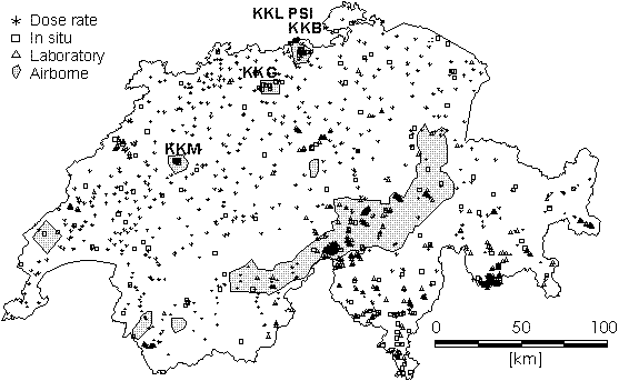
| Fig. 1: |
Distribution of the input data. Hatched areas have been surveyed by
airborne gamma ray spectrometry. Swiss nuclear facilities: KKB = nuclear powerplant
Beznau, KKG = nuclear powerplant Gösgen, KKL = nuclear powerplant Leibstadt, KKM =
nuclear powerplant Mühleberg, PSI = Paul Scherrer Institute. |
The measuring system consists of a helicopter-borne gamma-ray spectrometer with data
control and storage and flight positioning instrumentation. The spectrometer covers the
gamma-ray energy range of 40 keV to 3000 keV with 256 channels. An
additional channel is used for the registration of high energy cosmic radiation. The
detector used for the survey consists of a package of four
4" x 4" x 16" prismatic, thallium-doped, sodium iodide
crystals (total volume 16.8 L). A PC-based data acquisition system synchronizes and
controls the measurements. The spectrometer data are collected every second together with
radar altitude, time, barometric pressure, outside air temperature and aircraft attitude
angles. Positioning is done with the satellite navigation system GPS [5].
Processing covers the common calibration and reduction procedures (cosmic and
background correction, spectral stripping, altitude correction) extended with an
additional topographical correction to account for the effects of the rugged topography in
the Swiss Alps. The data processing procedures adopted in this project, in particular for
reducing the effects of topography on airborne gamma-ray spectrometry measurements, are
described in [3] and [6].
2.2 In situ gamma-ray spectrometric
measurements
The in situ gamma spectrometric data were collected by the Branch for Radioactivity
Surveillance of the Federal Office of Public Health (SUeR). A total of 166 points are
monitored for environmental radioactivity, particularly in the neighbourhood of nuclear
installations and factories handling, processing or producing radioactive material ([7]
and [8]).
The measuring instrument consists of a portable germanium detector system with
4096 channels. In addition to the in situ measurement, which lasts for about two
hours, soil samples were collected from different depths for subsequent laboratory
analysis.
2.3 Dose rate measurements
At the time of the in situ spectrometric measurements, a dose rate measurement with a
Reuter-Stokes ionization chamber (RSS 111) was taken at every location. Many more
measurements were made subsequently (especially inside houses) to give a more detailed map
[9].
Data from 282 sites reported from an older survey with a 25 L, air-filled
ionisation chamber instrument were also included [10]. Recent emergency preparedness
exercises of the Swiss National Emergency Operation Centre (NAZ) with Geiger-Mueller (GM)
counters contributed 389 additional points. The instrument used was the Automess
6150 AD2, calibrated to measure the total dose rate, and the measuring time was one
hour [11].
2.4 Laboratory measurements
Since the late 1960's, 612 surface rock and soil samples have been analysed for
the natural radioelements, potassium, uranium and thorium, with a laboratory sodium iodide
system at the Geophysics Institute, ETH. The aim of these measurements was mainly to
determine heat production ([12], [13] and [14]). Since 1990 these measurements have been
performed with a modern high purity germanium system from Intergamma (efficiency 26%) with
4096 channels.
3 Calibration
When combining these datasets, it is essential to account for the fact that they have
been acquired with different methods. In particular, the representative volumes are
different. An airborne measurement represents the topmost 50 cm in an area of about
300 m x 300 m. An in situ or dose rate measurement represents a much
smaller area of 10 m x 10 m. The smallest volume is represented by the
sample measurements which are normally carried out on 0.5 kg of material.
The in situ measurements were calibrated using the soil samples taken with every set of
measurements. Experience showed that five to ten samples per site were enough for the
calibration. Since the artificial isotopes are not distributed homogeneously in the soil a
depth profile is taken to determine their distribution. The error of an in situ gamma
spectrometric measurement can be estimated at about ± 20% for each isotope.
The airborne data were calibrated using a combination of in situ measurements and rock
sample data. Since the airborne measurements cover a much larger sample area, an average
of four in situ measurements and 50 rock samples in different lithological units were
used for the calibration. Table 1 lists the calibration factors obtained.
The ground activities in Becquerels per kilogram have been converted to dose rates in
nanoSieverts per hour using the following conversion factors (in nSv/h per Bq/kg): 0.05
for 40K, 0.51 for 214Bi, 0.71 for 208Tl and 0.17 for 137Cs [8]. Other isotopes (134Cs,
60Co, 7Be, etc...) occur only in traces and were neglected for this application. In the
uranium and thorium decay chains, equilibrium up to the isotopes 226Ra, 228Ac,
respectively, was assumed.
Table 1: Calibration factors for the airborne system (calculated from count
rates measured with the airborne system at 120 m flight altitude and activity
determinations in Bq/kg at ground).
| Isotope |
137Cs |
40K |
214Bi |
208 Tl |
| cps in window per Bq/kg |
0.500 |
0.090 |
0.268 |
0.418 |
4 Collation/interpolation/mapping
The radiation at a point is composed of three components:
| - |
Cosmic background: The intensity of the radiation due to cosmic rays
depends mainly on the thickness of the atmosphere above the measurement location, and
therefore mainly on altitude above sea level. Neglecting the effects of air pressure, the
cosmic background can be considered constant in time. |
| - |
Natural terrestrial radiation: Terrestrial radiation is mostly produced by
the decay of the four natural radio isotopes 235U, 238U, 232Th and 40K. |
| - |
Artificial terrestrial radiation: Sometimes contributions of long-lived
decay and activation products from nuclear weapon tests and/or nuclear facilities (mainly
137Cs) add to the natural contributions. The artificial radiation at the surface varies
with time due to decay and downward migration of caesium. |
The cosmic contribution of the radiation was calculated from a digital terrain model
averaging topographic heights within a cell size of 2 km x 2 km using
the relation:
Dcosmic [nSv/h] = 37.0 exp ( 0.38 altitude [km] ) [8]
which yields a map of the cosmic background in Switzerland (Fig. 2).
The map of the natural terrestrial radiation assembles the airborne gamma-ray
spectrometry, in situ gamma-ray spectrometry and rock/soil sample data. In addition to the
airborne data, a total of 1615 ground data points were available for the map
production.
The variations in the natural dose rate (terrestrial and cosmic) due, for example, to
radon washout, soil humidity, snow cover and sun activity are around 25%, and were
neglected for this work. The artificial part of the radiation poses a specific problem.
Since this contribution is not constant in time, the value depends on the time of the
measurements.
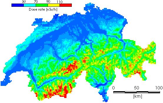
| Fig. 2: |
Cosmic dose rate map (in nSv/h) of Switzerland. Min. value: 40 nSv/h;
Max. value: 191 nSv/h; Average value: 64 nSv/h; Std. deviation 22 nSv/h. |
In particular, data recorded in 1986 are strongly influenced by the fallout from
Chernobyl. The map of the artificial radiation was therefore produced only using data from
in situ and airborne spectrometric measurements taken after 1987, which yielded
167 data points. Laboratory measurements on rock samples could not be used for the
map of artificial radiation, since they are usually taken from an unweathered (covered)
part of a rock, and are therefore devoid of any artificial radioactive isotopes. This map
(Fig. 4) has the smallest data base.
The total dose rate map of Switzerland was calculated by summing the previously
described maps (cosmic, natural terrestrial and artificial dose rate).
For the interpolation of the maps, a simple inverse distance method with a search
radius of 12 km and cell size of 2 km x 2 km was chosen. In areas
with airborne data coverage the search radius was decreased to 2 km to give better
spatial resolution.
Because of the generally large statistical errors in radiometric data, the sharp
changes in radioactive field intensities and the inhomogeneous data point distribution the
classical isoline representation was abandoned and the pixel representation was used (for
details see [3] and [15]). The values on the maps are given in a 25-grade linear color
scale (blue cyan green yellow red: increasing
values). The color ranges are given on the respective figures, along with the maximum,
minimum, and mean value with standard deviation.
5 Results and conclusions
By assembling different ground radiation datasets and after appropriately converting
the measured values, a dose rate map of Switzerland could be constructed. It relies on a
data base which corresponds to a density of about 1 point per 25 km2.
The map of the cosmic radiation (Fig. 2) shows elevated dose rates in the high
parts of the Swiss Alps. The cosmic dose rate ranges from 40 to 190 nSv/h, according
to the altitude.
The terrestrial natural dose rate map presented in Fig. 3 shows general agreement
with lithology: elevated dose rates (100 to 200 nSv/h) characterize the Central
Massifs of the Alps where crystalline rocks give a maximum dose rate of 370 nSv/h,
whereas the sedimentary northern Alpine Foreland (Jura, Molasse Basin) shows consistently
lower dose rates (40 - 100 nSv/h). The ground radiation can show short-term
changes. After rainfall, the short-lived daughter products of atmospheric radon are
deposited on the ground; they can increase the dose rate for about a day by several tens
of nSv/h.
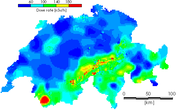
| Fig. 3: |
Natural terrestrial dose rate map (in nSv/h) of Switzerland. Min. value:
6 nSv/h; Max. value: 368 nSv/h; Average value: 68 nSv/h; Std. deviation
35 nSv/h. |
The artificial radiation map (Fig. 4) has its maximum value in the southern part
of Switzerland (90 nSv/h). In this region it rained soon after the Chernobyl
accident, so the airborne aerosols with radioactive isotopes were washed out and
deposited.
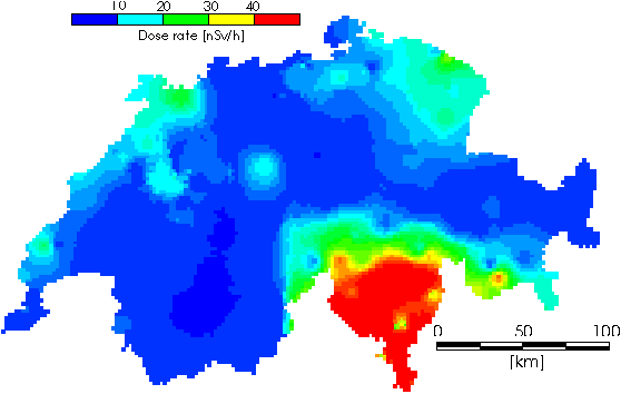
| Fig. 4: |
Artificial dose rate map (in nSv/h) of Switzerland. Min. value:
1 nSv/h; Max. value: 91 nSv/h; Average value: 11 nSv/h; Std. deviation
14 nSv/h. |
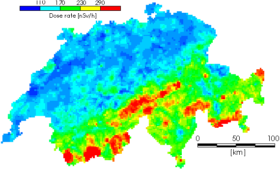
| Fig. 5: |
Total dose rate map (in nSv/h) of Switzerland. Min. value: 55 nSv/h;
Max. value: 569 nSv/h; Average value: 147 nSv/h; Std. deviation 59 nSv/h. |
And finally the map of the total dose rate of Switzerland is presented (Fig. 5),
which corresponds roughly to the sum of the above three maps (with additional data points
from the dose rate measurements). The values range from 55 to 570 nSv/h. The dose
rate frequency distribution derived from the total dose rate map by counting the pixels in
each interval is shown in the histogram of Fig. 6. The predominance of the dose rate
range 85 - 115 nSv/h is evident.
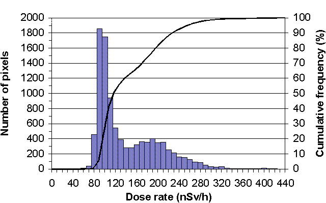
| Fig. 6: |
Dose rate frequency distribution in Switzerland. |
These values are considerably higher that reported in the Radiation Atlas
("Natural Sources of Ionising Radiation in Europe") published by the European
Communities
(60 - 70 nSv/h).
In summary, by properly treating the non-uniform data base available, a consistent
ground radiation map of Switzerland has been established. The results indicate the dose
rate varies over about one order of magnitude and the most frequent radiation level is in
the range 85 - 115 nSv/h (total dose rate outdoors).
Acknowledgements
This mapping study was performed within the project framework of the Swiss Federal
Nuclear Safety Inspectorate. We thank Dr. S. Prêtre and W. Jeschki (Würenlingen) for
continuous support and valuable discussions.
Contribution no. 913, Institute of Geophysics ETH Zurich.
References
| [1] |
RYBACH, L., SCHWARZ, G.F., Ground gamma radiation maps: processing of
airborne, laboratory and in sity spectrometry data, FIRST BREAK 13 (1995) 97-104. |
| [2] |
WOLLENBERG, H.A., REVZAN, K.L. and SMITH, A.R., Application of airborne
gamma spectrometric survey data to estimating terrestrialgamma-ray dose rates: An example
in California, Health Physics 66 (1994) 10-16. |
| [3] |
SCHWARZ, G.F., KLINGELE, E.K., RYBACH, L., Airborne radiometric mapping in
Switzerland. Beiträge zur Geologie der Schweiz, Geophysik Nr.25. Schweizerische
Geophysikalische Kommission, Institut fürGeophysik der ETHZ, Zürich (1992a). |
| [4] |
SCHWARZ, G.F., KLINGELE, E.K., RYBACH, L., Aeroradiometrische Messungen in
der Umgebung der schweizerischen Kernanlagen, Berichte zuhanden der Hauptabteilung für
die Sicherheit der Kernanlagen (HSK), Interne HSK-Berichte, Hauptabteilung für die
Sicherheit der Kernanlagen, Villigen, Switzerland (1989, 1990, 1991 and 1992). |
| [5] |
SCHWARZ, G.F., RYBACH, L., BAERLOCHER, C.K., KLINGELE, E.E., Development
and calibration of an airborne radiometric measuring system, In: "Application of
Uranium Exploration Data and Techniques in Environmental Studies", IAEA-TECDOC-827,
Vienna (1995a) 25-34. |
| [6] |
SCHWARZ, G.F., RYBACH, L., KLINGELE, E.K., How to handle rugged topography
in airborne gamma-ray spectrometry, First Break 10 (1992b) 11-17. |
| [7] |
MURITH, C., VOELKLE, H.R., SURBECK, H., PILLER, G., BAERISWIL, L., BEURET
P., FERRERI, G., GOBET, M., GURTNER A., RIBODRY, L., Mesures in situ - mesures
aéroradiométrie dans le voisinage du PSI, Interner SUeR-Bericht, Bundesamt für
Gesundheitswesen, Sektion zur Überwachung der Radioaktivität, Fribourg, Switzerland
(1991). |
| [8] |
MURITH, C., GURTNER A.,. Mesures in situ et irradiation externe, In:
"Environmental Radioactivity and Radiation Exposure in Switzerland"/ Annual
Reports 1990, 1991, 1992 and 1992, BAG-Bericht. Bundesamt für Gesundheitswesen, Abteilung
Strahlenschutz, Bern, Switzerland (1990, 1991 and 1992). |
| [9] |
JOHNER, H.U., VOELKLE, H.R., Die natürliche terrestrische und kosmische
Strahlung im Hausinnern, In "Environmental Radioactivity and Radiation Exposure in
Switzerland"; Annual Report 1993. Bundesamt für Gesundheitswesen, Abteilung
Strahlenschutz, Bern, Switzerland (1993). |
| [10] |
HALM, E., HERBST, W., MASTROCOLA, A., Messung des natürlichen
Strahlenpegels in der Schweiz, Bulletin des Eidg. Gesundheitsamtes, Beil. B Nr. 6
(1962) 133-167. |
| [11] |
RAUBER, D., Übung NARACH der Nationalen Alarmzentrale (NAZ), Allgemeine
Schweizer Militär-Zeitschrift (Verlag Huber & Co, Frauenfeld) 11 (1993) 498-500. |
| [12 ] |
SCHAERLI, U., Geothermische Detailkartierung (1:100'000) in der zentralen
Nordschweiz mit besonderer Berücksichtigung petropysikalischer Parameter, Dissertation
ETH Nr.8941, Eidgenössische Technische Hochschule, Zürich (1989). |
| [13] |
RYBACH, L., LABHART, T.P., Regelmässigkeiten der
Radioaktivitäts-verteilung in granitischen Gesteinskörpern (Beispiele aus den Schweizer
Alpen), Schweizerische Mineralogische und Petrographische Mitteilungen 53 (1973) 379-385. |
| [14] |
LABHART, T.P., RYBACH, L., Abundance and distribution of uranium and
thorium in the syenite of Piz Giuv (Aar-Massif, Switzerland), Chemical Geology 7 (1971)
237-251. |
| [15] |
SCHWARZ, G.F., RYBACH, L., KLINGELE, E.E., Data processing and mapping in
airborne radioactivity systems, In: "Application of Uranium Exploration Data and
Techniques in Environmental Studies",IAEA-TECDOC-827, Vienna (1995b) 61-70. |